Michigan Dreaming Bucket List: Your guide to hiking state's tallest peak
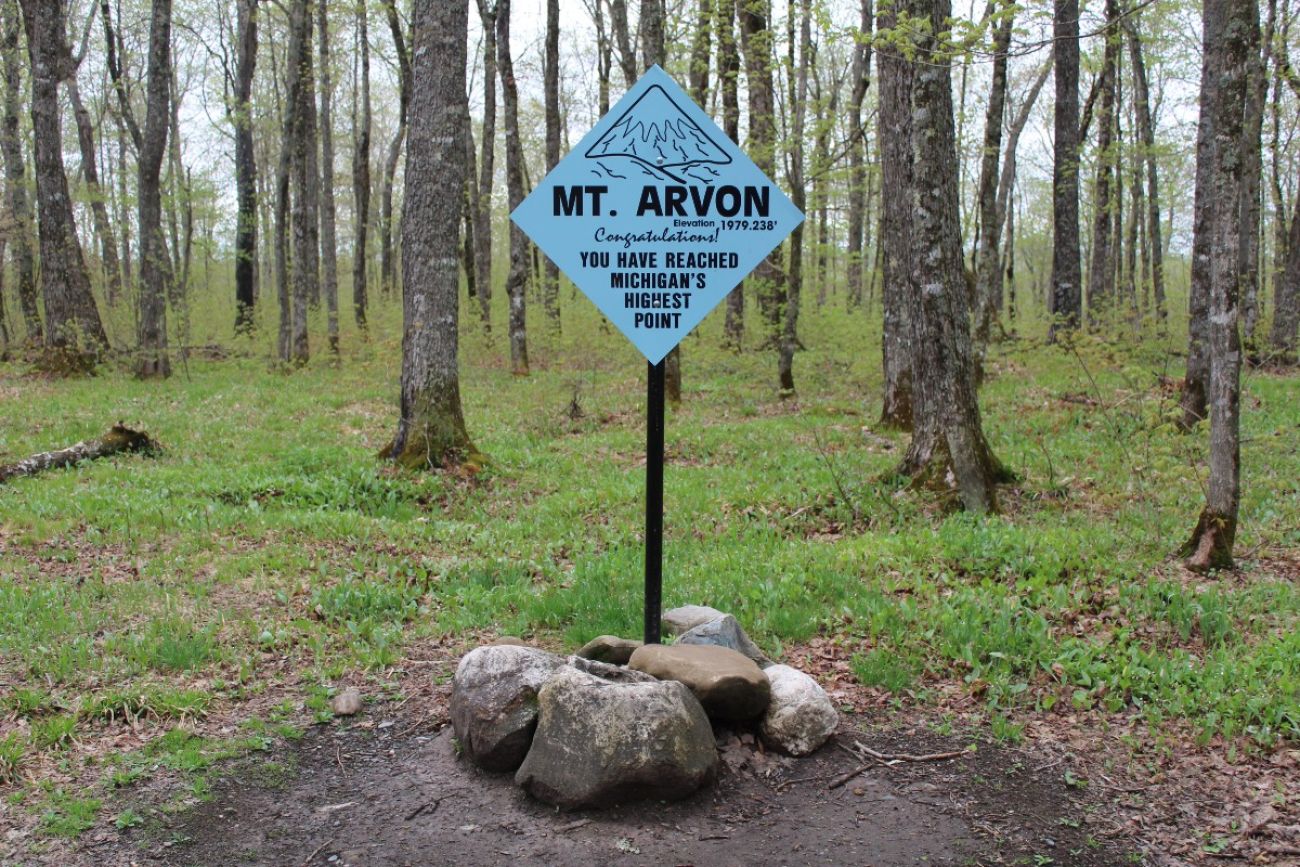
- At 1,979 feet, Mount Arvon in the Huron Mountains of the Upper Peninsula is considered Michigan’s highest natural point, though not without some caveats
- The shortest trail to the summit takes a matter of minutes, but the drive to the trailhead can be arduous
- Items at the top include a special sign, a mailbox with a notebook and what looks like a gravestone
Mount Arvon, located in Baraga County in the Upper Peninsula’s Huron Mountains, is considered the state’s official high point.
But there are a lot of caveats.
Until 1982, Mount Curwood, another peak in the Huron Mountains, was considered the state’s high point. In 1982, the US Department of Interior’s Geological Survey team took new measurements and concluded that Mount Arvon is 1,979.24 feet tall, 11 inches higher than Mount Curwood.
The change threw a wrench in the works for highpointers, people who try to hike the high point in every US state.
“A lot of the old-timers that did Mount Curwood came back and did Mount Arvon, just to make sure that they still got their high points,” said Barb McEwen, the executive director of the Baraga County Convention and Visitors Bureau in L’Anse.
To make matters more complicated, though Mount Arvon is considered the highest natural point in Michigan these days, it’s not the actual highest point in the state. A stockpile of sediment at Tilden Mine in the UP’s Tilden Township is a little bit taller than 2,000 feet, according to the National Oceanic and Atmospheric Administration and a topographical map in the mine's own documents.
Michigan Dreaming Summer Bucket List
Reaching the top of Mount Arvon is #6 on the Michigan Dreaming Summer Bucket List. See the full list here.
RELATED:
- Voted by you: 10 Michigan gems to add to your summer bucket list
- Michigan’s newest campground will showcase popular Marquette cliff, 'The Rock Cut'
- Michigan researchers study hawks in migration hot spot the Mackinac Straits
Still, there’s something to be said about making it to the top of a state’s official natural high point.
“You feel like you’ve won something,” said Derek van Westrum, gravity and heights program manager for a division of NOAA that supports mapping. “You just can’t help but think there’s nobody else in this entire state that’s higher than I am right now.”
Unless, of course, you’re on Mount Arvon while someone’s driving a bulldozer on the tallest stockpile at Tilden Mine.
Here’s a guide to summiting Mount Arvon, including some background info on unexpected items at the top, like a mailbox and what looks like a gravestone.
How to get there
When it comes to Mount Arvon, people like to say the hardest part is driving there. Whether you’re coming from L’Anse or from Marquette, you’ll need to go down logging roads in the middle of the Huron Mountains with little to no cell service to get to a trailhead to the summit.
Sign up for our outdoors newsletter
Want more coverage like this delivered directly into your inbox? Sign up for the Bridge Michigan Outdoors newsletter here.
If you head there from L’Anse, blue diamond-shaped signs will lead the way. But, if you’re coming in from a different direction, grabbing a paper map or screengrabbing directions before you hit the road is a good idea. Be ready to make a plan B if map app directions take you to a washed-out road. In that case, remember you can still use GPS in your map app even if you don’t have cell service.
The road is bumpy and slow-moving, so a vehicle with high clearance is recommended. Avoid the road during heavy rains or when snow is on the ground, as you might get stuck. According to the Baraga County Convention and Visitors Bureau, the last two miles of the road is sometimes closed in the spring (to prevent damage to the road during the rainy season), but, if that’s the case, you can walk the last two miles.
Hiking the summit
The hike to the top is not much of a feat. For most of the year, when the road is open, you can drive to the upper parking lot and take a 0.1-mile out-and-back trail to the top. Or, if you’re up for a little bit more of an adventure, you can park your car at 46.7633705, -88.1440275 and take a 2-mile out-and-back hike that passes a couple waterfalls.
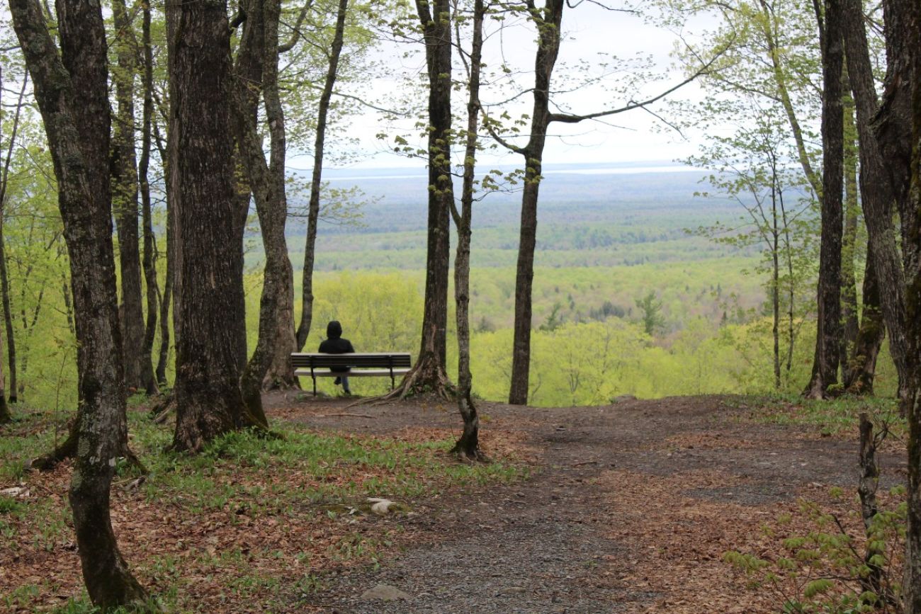
There’s a view, but it’s not at the top
If you’re expecting a breathtaking view from the top of Mount Arvon, think again. The actual peak is in the middle of the woods and there’s no view.
However, about 100 meters from the top, you’ll encounter a bench and a view of the Huron Mountains. The overlook was added in 2008 by the landowner at the time, Plum Creek. The land’s currently owned by a logging company but is accessible to the public through an easement and partnership with the state.
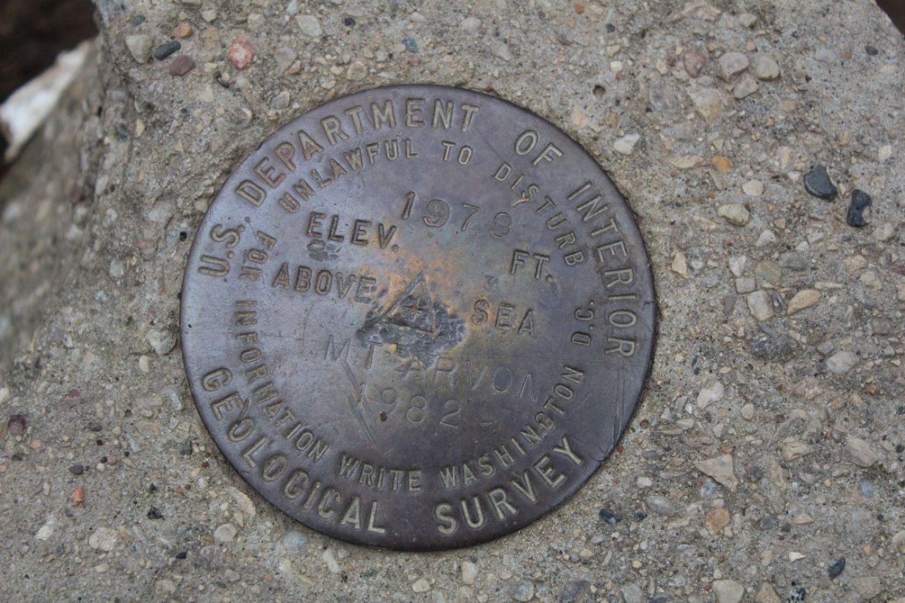
There’s an elevation marker at the top
At the top, there’s a circular metal marker from the US Department of Interior Geological Survey that says “1979 ELEV. FT. ABOVE SEA MT. ARVON 1982.” It also says “UNLAWFUL TO DISTURB FOR INFORMATION WRITE WASHINGTON D.C..”
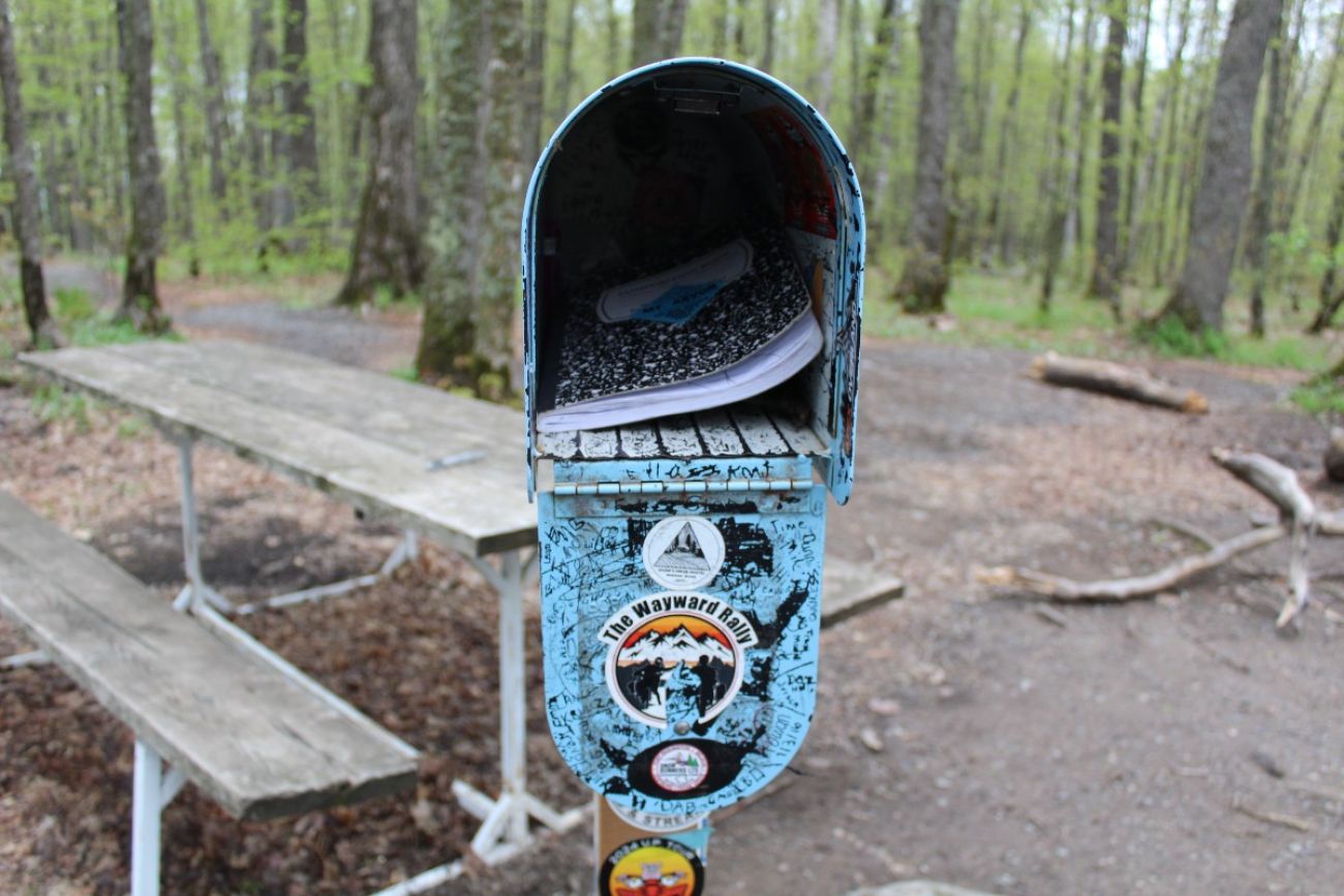
You can write your name in a notebook
There’s also a mailbox at the summit. Inside is a notebook in which you can log that you made it to the top.
Some recent entries included this one from Sam Smith Jr.: “This place was on my bucket list! Made it on my birthday, May 14, 2025 (64 years old).”
An anonymous entry said: “This is my favorite spot (Huron Mtns) I hope to someday have my ashes droped (sic) here. 1-9-2025”
The notebooks go back to at least 1995. An archive is kept at the Baraga County Convention and Visitors Bureau. McEwen said that, sometimes, people come by hoping to see the archive.
“I've, in the past, had people come here and say ‘I went there around deer season of such and such year. Can you look up the post? Because so-and-so passed away that was with me and signed the book.’”
If something like that happens, McEwen will make a photo copy of the entry and give it to the visitor.
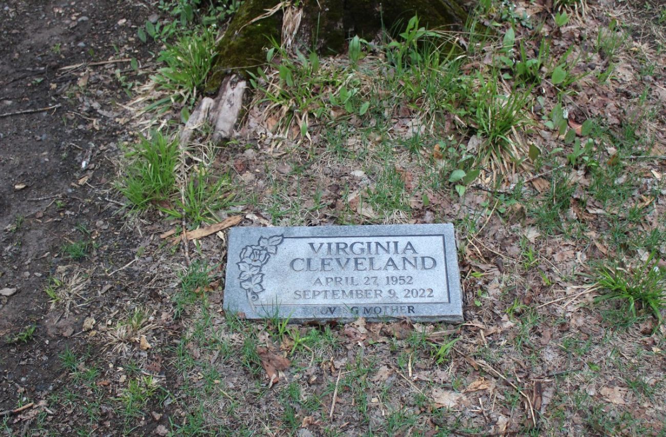
Is someone buried at the top?
When Bridge Michigan visited on May 17, there was what looked to be a gravestone at the top for a Virginia Cleveland.
According to the marker, Cleveland was born on April 27, 1952 and died on Sept. 9, 2022. This online obituary suggests Cleveland was from Jackson, Mississippi. Searches on LexisNexis and newspapers.com revealed no obvious ties to Michigan. Little to no other information about her is publicly available.
According to McEwen, Cleveland is not buried at the top of Mount Arvon, but the engraved stone is just a memorial marker left without permission. She said three or four of them were left last year.
“Multiple people were putting them up, memorial spots, and the land company asked for them to be removed,” she said.
McEwen has been trying to find family members related to Cleveland to get them to remove the marker, but she hasn’t had any luck.
No camping allowed
Also at the top is a picnic table, a firepit and a grill. Those are for day use only. Camping is not permitted on Mount Arvon.
Who owns the land?
Ownership of the land Mount Arvon sits on has changed hands quite a bit.
Past owners have included Plum Creek, Weyerhaeuser and MeadWastvaco. It’s currently owned by Lyme Great Lakes Timberlands, the largest private land owner in the state. The company is an affiliate of Lyme Timber Co., based in Hanover, New Hampshire.
General Manager Bill O’Reilly said the land where Mount Arvon sits is enrolled in Michigan’s Commercial Forest Program, which reduces the company’s property taxes and allows public access for hunting and fishing. It’s also part of a conservation easement project with the state, which O’Reilly said will “keep that open for vehicles forever.”
You can get a certificate for going to the top
If you stop at the Baraga County Convention and Visitors Bureau and prove you made it to the top with photographic evidence, you will be rewarded with a certificate. The certificate was started by Tracey Barrett, the bureau’s previous executive director. She said she created the certificate after a visitor told her that they handed them out if you hiked the high point in Illinois.
Want to shout your achievement from the mountaintops?
Many people don’t stop at Mount Arvon. They go on to hike the high point in every state. If you’re interested in doing the same, you can join the Highpointers Club and/or post when you reach various highpoints like Mount Arvon at peakbagger.com.

See what new members are saying about why they donated to Bridge Michigan:
- “In order for this information to be accurate and unbiased it must be underwritten by its readers, not by special interests.” - Larry S.
- “Not many other media sources report on the topics Bridge does.” - Susan B.
- “Your journalism is outstanding and rare these days.” - Mark S.
If you want to ensure the future of nonpartisan, nonprofit Michigan journalism, please become a member today. You, too, will be asked why you donated and maybe we'll feature your quote next time!