Map reveals Michigan National Guard’s proposed Camp Grayling expansion
June 23: National Guard on Camp Grayling expansion: Troops won’t be in your backyard
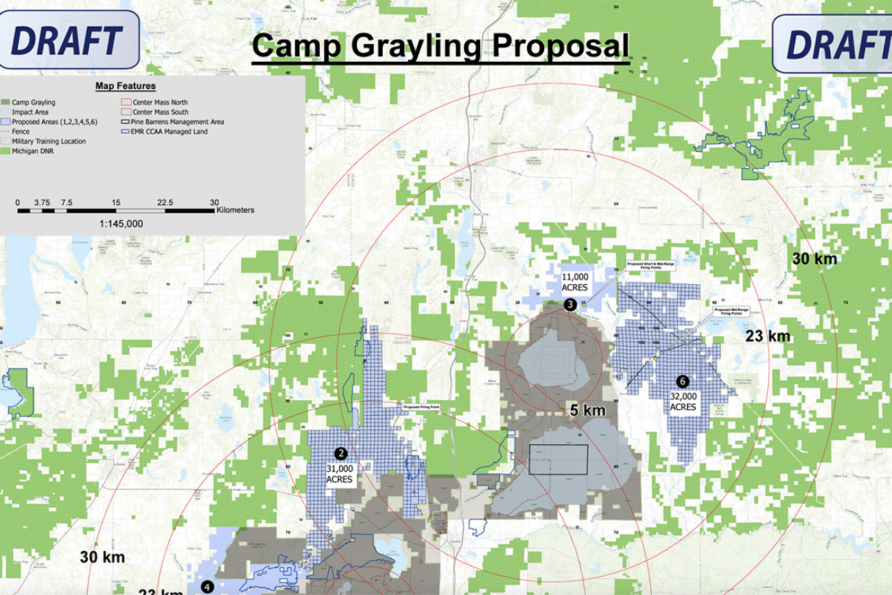
A new map provided by the Michigan Department of Natural Resources provides a detailed view of the state lands targeted for a proposed Camp Grayling expansion that would more than double the Michigan National Guard training facility’s footprint in Northern Michigan.
The proposed expansion includes large tracts to the north, south, east and west of the existing 148,000-acre camp, some of it adjacent to the Au Sable and Manistee rivers.
There, National Guard officials say they plan to perform “low-impact” training designed to prepare soldiers for modern warfare that’s as likely to involve cyber attacks as bombs and bullets.
The map released by the DNR includes only some named roads, rivers and other geographic markers, but does reveal the boundaries of an expansion proposal that will soon be up for public comment.
You can see a zoomable PDF version of the draft map here.
DNR officials are considering whether to accept the proposal, submitted in early 2022 and first detailed publicly in Bridge Michigan last week. Bridge spoke with Tom Barnes, manager of the DNR’s Grayling Forest Management Unit, about the process ahead. Here’s what you need to know:
Where is the proposed expansion?
It includes large parcels of state-owned land branching off in multiple directions from the existing camp surrounding the city of Grayling. In total, the proposed expansion comes to more than 160,000 acres.
The area proposed for military use encompasses almost all of the wetlands visible from US-127 west of Houghton and Higgins lakes. It also includes stretches of the Manistee and the Au Sable rivers, though Camp Grayling Commander Col. Scott Meyers told Bridge Michigan in an interview last week that training exercises will not take place near those stretches of river.
How would this change Camp Grayling’s footprint?
The training zone would more than double in size. Camp Grayling’s existing footprint is about 148,000 acres, most of it on state land.
Related: Michigan National Guard wants to double Camp Grayling training land
Though the camp was established in 1913 with a land gift from lumber baron Rasmus Hanson, state land donations and leases have been its primary means of expansion in the century-plus since.
Camp Grayling’s state land accrual started with a 40,000-acre donation in 1934, and the Guard has since acquired long-term leases on 57,000 acres, plus shorter-term leases on another 43,000 acres, Barnes said.
“We’ve had a long history of working with the military,” he said.
How would the National Guard use the land?
Last week, Meyers told Bridge Michigan the National Guard would conduct only “low impact” training on the proposed expansion lands. There would be no new trails built for tanks, no bombing or shooting, no new buildings or fences.
Instead, Meyers said, the typical exercise might involve soldiers camping in the woods with satellites, training for electronic and cyber warfare.
But a draft map of the proposal also includes proposed “firing points,” which Barnes described as areas where the military sets up weaponry to fire into existing ranges. Meyers could not immediately be reached Wednesday afternoon to clarify the National Guard’s intentions at those sites.
How will the changes affect public lands users?
For the most part, Barnes said, “you're not gonna see a whole lot of difference.”
Training exercises on the proposed expansion landscape would be limited in duration and confined to small areas, Meyers said. Though troops involved in cyber warfare training would need vast swaths of land to avoid jamming signals of other groups nearby, he said, their physical footprint on the land would be minimal.
Still, Barnes told Bridge, there will likely be occasional road or area closures. He doesn’t anticipate any of them affecting access to the Manistee or Au Sable rivers. As for impacts to the wilderness experience for hunters, anglers, hikers, mushroom pickers and the like?
“The user experience is already being impacted,” he said. “When you’re in Grayling and you fish in any of these rivers, you hear the rat-a-tat-tat of the machine guns. You hear the strafing around of the A-10s. You hear the helicopters, you see them flying over.”
Would Michigan get anything in return?
The National Guard reimburses Michigan for costs known as “payments in lieu of taxes,” that Michigan taxpayers would otherwise pay to reimburse local governments for lost property tax opportunities on public lands.
Barnes said he would anticipate a similar arrangement if the DNR agreed to the expansion proposal. He did not have an estimated dollar figure for how much the DNR could expect to save.
The National Guard also helps pay for certain management duties on lands it leases, such as trimming trees and managing species.
Is this map final?
No.
“This is just a draft,” Barnes stressed, and the borders will almost certainly change if the DNR goes through with the deal.
Some parcels within the proposed expansion area are not eligible for military use. Property purchased with money from the Natural Resources Trust Fund, for example, must be used for public recreation or land protection.
What happens next?
DNR officials plan to meet later this month with river and angling groups who have expressed worry that an expanded military presence in the forest could hinder recreation, public access and livability.
Barnes said the DNR will also host a public meeting sometime in early June, followed by a public comment period. For now, he said, the agency is neutral on the proposal and there is no timeline for a decision, he said.
The military would also have to go through an environmental review process before establishing any new training areas, he said.


Michigan Environment Watch
Michigan Environment Watch examines how public policy, industry, and other factors interact with the state’s trove of natural resources.
- See full coverage
- Subscribe
- Share tips and questions with Bridge environment reporter Kelly House
Michigan Environment Watch is made possible by generous financial support from:


Our generous Environment Watch underwriters encourage Bridge Michigan readers to also support civic journalism by becoming Bridge members. Please consider joining today.
See what new members are saying about why they donated to Bridge Michigan:
- “In order for this information to be accurate and unbiased it must be underwritten by its readers, not by special interests.” - Larry S.
- “Not many other media sources report on the topics Bridge does.” - Susan B.
- “Your journalism is outstanding and rare these days.” - Mark S.
If you want to ensure the future of nonpartisan, nonprofit Michigan journalism, please become a member today. You, too, will be asked why you donated and maybe we'll feature your quote next time!