Republicans’ hold on Lansing power could grow with new redistricting maps
Oct. 15: Michigan redistricting panel’s maps spark racial backlash, fairness questions
Oct. 11: Michigan redistricting drafts could make state Senate a toss-up
Oct. 11: Michigan congressional redistricting drafts are done. Few incumbents are safe
Oct. 11: Republicans have edge, but Michigan House drafts include plenty of surprises
LANSING — Michigan’s citizen redistricting panel has wrapped up its proposed state legislative maps, and they could give Republicans an even bigger advantage than when they drew the districts themselves.
Despite suing to block the creation of the Michigan Independent Redistricting Commission, Republicans could retain if not grow their advantage in 110 House of Representative districts and 38-seat state Senate, according to a Bridge Michigan analysis comparing 2020 vote tallies to the new districts.
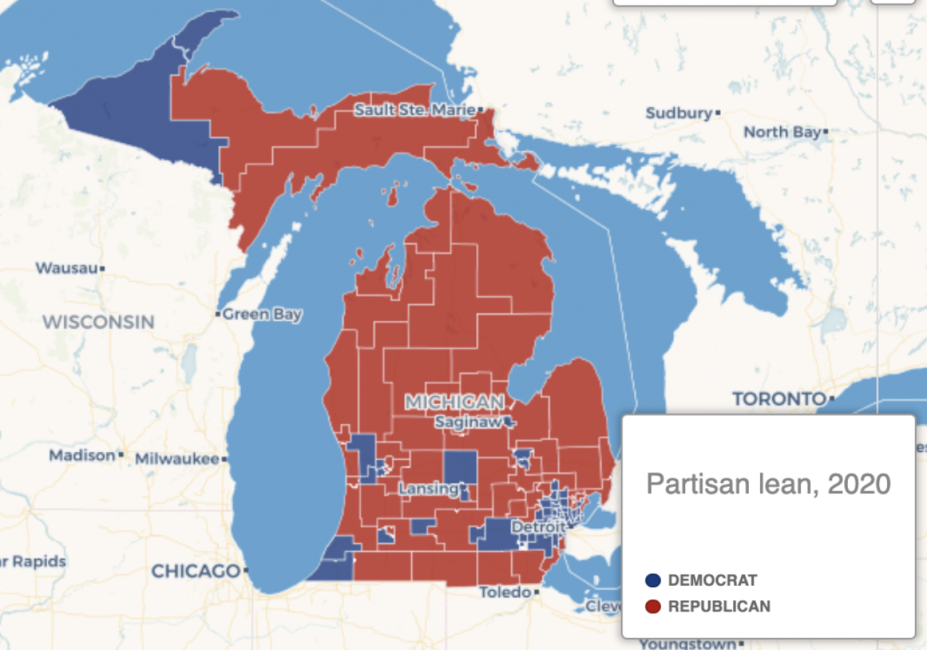
Proposed Michigan House map retains GOP advantages
A preliminary map drafted this week would, if approved, create new state House districts in which Republicans would have an advantage in 58 of the 110 districts, based on 2020 presidential election results. Using 2016 results, when former President Donald Trump won, the new map skews even more heavily Republican, with 66 of the districts won by Trump.
Source: Bridge Michigan analysis of maps provided by the Michigan Independent Citizens Redistricting Commission
The House districts, now split 58-52 in favor of the GOP, would still have at least 58 seats leaning or solidly Republican, using 2020 presidential or 2018 U.S. Senate results. When the 2016 presidential results are applied, that margin grows to 66-44 in favor of the GOP.
Related:
- Michigan’s next big election fight: absentee ballot signatures
- Few incumbents are safe in Michigan’s draft congressional district maps
- GOP still holds edge in Michigan map drafts, but Democrats could gain seats
- Michigan redistricting panel to miss maps deadline. More lawsuits may follow.
In the state Senate, a Bridge Michigan analysis found that proposed districts still favor Republicans, but Democrats could pick up one or two seats.
Republicans won 22 of 38 Senate seats in the 2018 election. That edge would shrink to 20-18 with the new maps if voting patterns from the 2020 election followed, and 21 to 38 if votes fell the way of the 2016 presidential contest.
“The monster (Democrats) created — the Michigan Independent (Citizens) Redistricting Commission — came up with an even more Republican gerrymandered map than the Republican Legislature came up with,” said Jamie Roe, a longtime GOP strategist.
“Imagine that.”
Voters created the 13-member citizens panel in 2018 after years of complaints about gerrymandering in Michigan, which like other states allowed the party in power in the state legislature after the decennial census to draw the districts.
In 2019, a panel of federal judges declared Michigan’s 2011 districts a “political gerrymander of historical proportions” after Democrats brought a lawsuit that produced bombshell emails showing Republicans plotted to “cram Dem garbage” in minority districts and map boundaries that would keep the GOP in power for years.
At first blush, though, the draft maps from the independent panel appear to support longtime Republican arguments that Michigan’s geographic divide leads to districts that favor GOP candidates.
New state Senate maps
Michigan’s nonpartisan redistricting committee has created a proposed set of Senate boundaries that would allow the GOP to keep its edge, but the Democrats to pick up a few seats. Use the map to see how each new district voted in the 2016 and 2020 presidential elections.
Source: Bridge Michigan analysis of maps provided by the Michigan Independent Citizens Redistricting Commission
From a purely geographic perspective, most of Michigan is Republican — with huge majorities in most of the Thumb, northern Michigan, Upper Peninsula and central Michigan.
Democrats have big advantages in urban areas with the most voters, such as Detroit, southeast Michigan suburbs, Flint and other cities.
Overall, the state leans Democratic, favoring Democrats for president in every election since 1992 except 2016. For instance, Democrats typically win 90 percent or more of the vote in Detroit, by far the state’s largest city.
To get a politically balanced map — which the Michigan Independent Citizen Redistricting Commission is not charged to do — would require connecting cities with far-flung townships and counties.
“Geography matters with drawing maps,” Roe said. “You have to draw snake districts to connect Democrat-voting bases to dilute Republican-voting bases in other areas.”
With the current maps, which could be voted upon this week, the commission did not choose to do that, keeping cities such as Saginaw and Flint intact and not stretching districts into neighboring rural areas as the existing districts do.
Although the commission has several proposed congressional maps, the one they have focused most attention upon is currently not complete enough to analyze.
Complicating matters is the loss of one district, with Michigan going from 14 to 13 congressional districts.
Nancy Wang, the executive director of Voters Not Politicians, the nonprofit behind the push for the citizen redistricting group, told Bridge Michigan the maps are far from done.
“The constitutional amendment makes it clear that these maps have to pass tests of partisan fairness, and we know that that process hasn't been undertaken by the commission,” Wang said.
“There will have to be an adjustment of the lines to comply with the partisan fairness requirements in the amendment.”
The commission is expected to get their maps analyzed for partisan fairness on Friday, and put out maps for public comment earlier next week.
The commission could adopt the final version of the maps on Dec. 30..


See what new members are saying about why they donated to Bridge Michigan:
- “In order for this information to be accurate and unbiased it must be underwritten by its readers, not by special interests.” - Larry S.
- “Not many other media sources report on the topics Bridge does.” - Susan B.
- “Your journalism is outstanding and rare these days.” - Mark S.
If you want to ensure the future of nonpartisan, nonprofit Michigan journalism, please become a member today. You, too, will be asked why you donated and maybe we'll feature your quote next time!