Shoreline erosion worries Michigan. Pictured Rocks cliff fall reminds why.
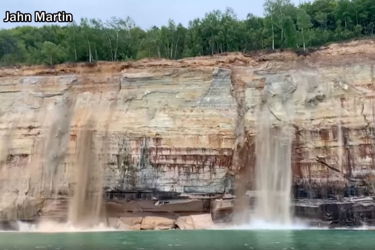
Kayakers who approach Michigan’s Pictured Rocks National Lakeshore regularly encounter evidence that its magnificent multicolored cliffs have dropped into Lake Superior over the centuries.
“There are always rocks in the water at the bottom of the cliffs,” said Susan Reece, chief of interpretation at the national park near Munising in the Upper Peninsula. “They are portions of a cliff that came off.”
Erosion, Reece said, “is always happening.”
But not typically in such dramatic fashion as was shown in a video captured last weekend by a boater: rivers of sand started to flow down the side of one of the famous cliffs just before a 200-foot section plummeted into the water.
No one was hurt, and the national park is making no changes to their operations or access, Reece said.
Related:
- Emergencies surge at northern Michigan parks, lakes. Time for a rescue tax?
- Yes, mosquitoes are worse in Michigan this summer. And it ain’t over
- People ignore drowning warnings, so Michigan may close Great Lakes beaches
- Loved to death: Iconic Michigan lakeshores battered by crowds, waste
- In tiny Copper Harbor, a mountain biking boom causes growing pains
- COVID supercharged Upper Peninsula travel. Looks like it’s going to last.
However, the large-scale erosion in action illustrates why state and national officials have elevated concerns about the vulnerabilities facing Michigan’s shoreline, both at the treasured 15-mile Pictured Rocks — one of the most distinctive natural areas in the state — and along all of the Great Lakes.
Reece said it’s unclear what may have caused the latest cliff drop and whether it’s a sign of accelerating erosion.
“We don’t know if it’s tied to climate change,” she said. “We don’t know if it’s tied to big changes in weather.”
The cliffs of Pictured Rocks are made of sandstone, a sedimentary rock made of quartz sand. It’s softer than granite, for example, and gives the cliffs their distinctive coloring.
Erosion isn’t unusual, Reece said, mentioning the 2006 collapse of a “turret” in the Miners Castle formation. But the size of the recent break caught Reece’s attention — though she said it wasn’t particularly alarming, given the scope of the park.
However, Lake Superior water levels have been high for the past couple of years, Reece said, causing added stress to shorelines. And, she added, erosion takes place more easily with heavy rains and high winds, which it’s faced in abundance since spring.
Monitoring Great Lakes water levels and the effects of climate changes took on added urgency in recent years, as rising water reached record levels during eight months of 2020. Before coronavirus turned into a deadly pandemic across the U.S., municipalities, Michigan officials, county drain commissioners, environmental organizations and business groups had identified lakeshore damage as a critical issue facing the state.
Damage estimates to Michigan’s shoreline roads were at least $100 million in early 2020, while the Michigan Municipal League said at least $63 million was needed to restore damage to city piers, utilities and recreational facilities.
In state parks, millions already had been spent on restoration as the rising water reached new heights, said Ron Olson, chief of the parks and recreation division of the state’s Department of Natural Resources. McLain, Muskallonge and Orchard Beach state parks all underwent major work to relocate buildings, restore roads or armor the shoreline.
On state-owned portions of Michigan’s 3,300-mile shoreline, Olson told Bridge Michigan, officials are dealing with “more and more seemingly violent storms in a condensed period of time, which has accelerated the battering of the shoreline.”
So far this year, water levels are receding from recent peaks. On Lake Superior, the water is 12 inches below the record monthly mean set in 2019, but it’s expected to remain above the typical mean for all of this year.
Officials at the state Department of Environment, Great Lakes and Energy say the drop in water levels is “eliminating most active wave erosion,” spokesperson Hugh McDiarmid said.
“However, that doesn’t mean that all shoreline areas are free from risk,” he said. “Wave cuts left many banks and bluffs over-steepened and devoid of vegetation. These areas are typically not stable and could be subject to dangerous mass failures.”
Both EGLE and Reece urge visitors to the state’s shoreline bluffs to use caution, especially as crowds increase during the peak summer travel season. Boaters on larger tours near Pictured Rocks should be safe from erosion issues, according to the park service. Kayakers should be cautious, notably if they notice sand falling, which could signal another larger-scale drop.
The same caution should be used near the edges of the bluffs, too, Reece said, noting that trees spotted hanging sideways or upside down along the cliffs “at one time were upright.”


See what new members are saying about why they donated to Bridge Michigan:
- “In order for this information to be accurate and unbiased it must be underwritten by its readers, not by special interests.” - Larry S.
- “Not many other media sources report on the topics Bridge does.” - Susan B.
- “Your journalism is outstanding and rare these days.” - Mark S.
If you want to ensure the future of nonpartisan, nonprofit Michigan journalism, please become a member today. You, too, will be asked why you donated and maybe we'll feature your quote next time!